Wednesday, August 09, 2017
Maol Chean-dearg (Strath Carron)
After a longish drive on a dull morning we set off from Coulags at about 7.20 to the sound of willow warblers singing, following the track past the works for a new hydroelectric scheme and crossing the river on a welcome footbridge.

A little way upstream was a dipper, with white feathers making a curious streak on its belly.

Some time later we came to a junction and turned left, climbing a zig-zag track as our hill came gradually into view.

A golden eagle appeared over a rocky prow ahead and then began to quarter the ridge of our hill.

I think it was a sub-adult bird, and the loss of some flight feathers reminds me that I made a mistake in a former post, implying of the sea eagles over Inverewe that their ragged plumage was caused by breeding. But of course these birds moult annually anyway, whether they go through the rigours of rearing young or not.
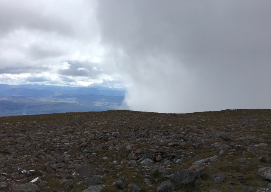
The path continued up, and was a foretaste of what was to come - being on white, slidy, quartzite scree. In the background are Sgorr Ruadh and Fuar Tholl, which we saw from the other (more interesting) side on our previous hill-walk.

Reaching the Bealach a' Choire Gharbh, we stopped for a breather and to admire the rocky Corbett of An Ruadh-stac. Some walkers take this in on the same walk, but we were confining ourselves to the Munro, and so turned off to the right to begin the ascent to the ridge. The path was again on quartzite scree, and this time it was very eroded and slippery, and pretty steep.

The best thing about rising above the bealach was encountering a breeze, which cooled us down as we climbed and also blew away the midges. There are two "steps" before the final summit dome is reached; this is the top of the first one, just after the scree path.

The summit is reached by negotiating that most dreaded of features - a boulder field. But after much balancing and swearing we got to the end of it and walked on the firmer ground of grass littered with smaller sandstone rocks to the huge summit shelter.


.....or at least, we did until what another walker who had arrived called "clag" (and he was Scottish, so he should know) closed in.
It crept in around our hill from the right, and then from the left, so that we were left with a tiny window - and then nothing. But it didn't prevent us from seeing a ptarmigan, whirring across the summit plateau and disappearing over the edge.
We waited until it had cleared before setting off down - the same way we'd come up, as the hill is said to be too steep elsewhere. But first I went over to the edge where the ptarmigan had last been seen, hoping to look down on a lower shelf where it might have landed; but sure enough, the ground was just too steep. Tucked in below this northern side is a fairly large lochan, but even that couldn't be seen. The path we had turned off from to climb up to the bealach continues past these lochans to Torridon - a fine walk if you're not interested in getting up on the tops; or you can simply use the paths to circumnavigate this hill and then return to Coulags.

Meanwhile we had to renegotiate the boulder field, and later, the slippery scree path down to the bealach - which was even worse going down.
Despite plenty of their droppings, we would have no more sightings of ptarmigan; and I had to be content with a pipit (presumably meadow) among the larger quartzite blocks.

As we made our way past the men at work with their diggers, Greger pointed out two grey wagtails on the far bank of the river; I heard and then saw a male stonechat; and the woodland at the end of the walk produced blue tit, goldcrest, and a large family or flock of long-tailed tits. The hill is 933 metres high and the walk was around 14 kilometres long; and with great will-power, I managed to avoid three of cheeky Greger's seven stages.
// posted by Christine @ 1:16 PM 
![]()